 IMAS Metadata Catalogue
climate change
Type of resources
Topics
Keywords
Contact for the resource
Provided by
Years
-
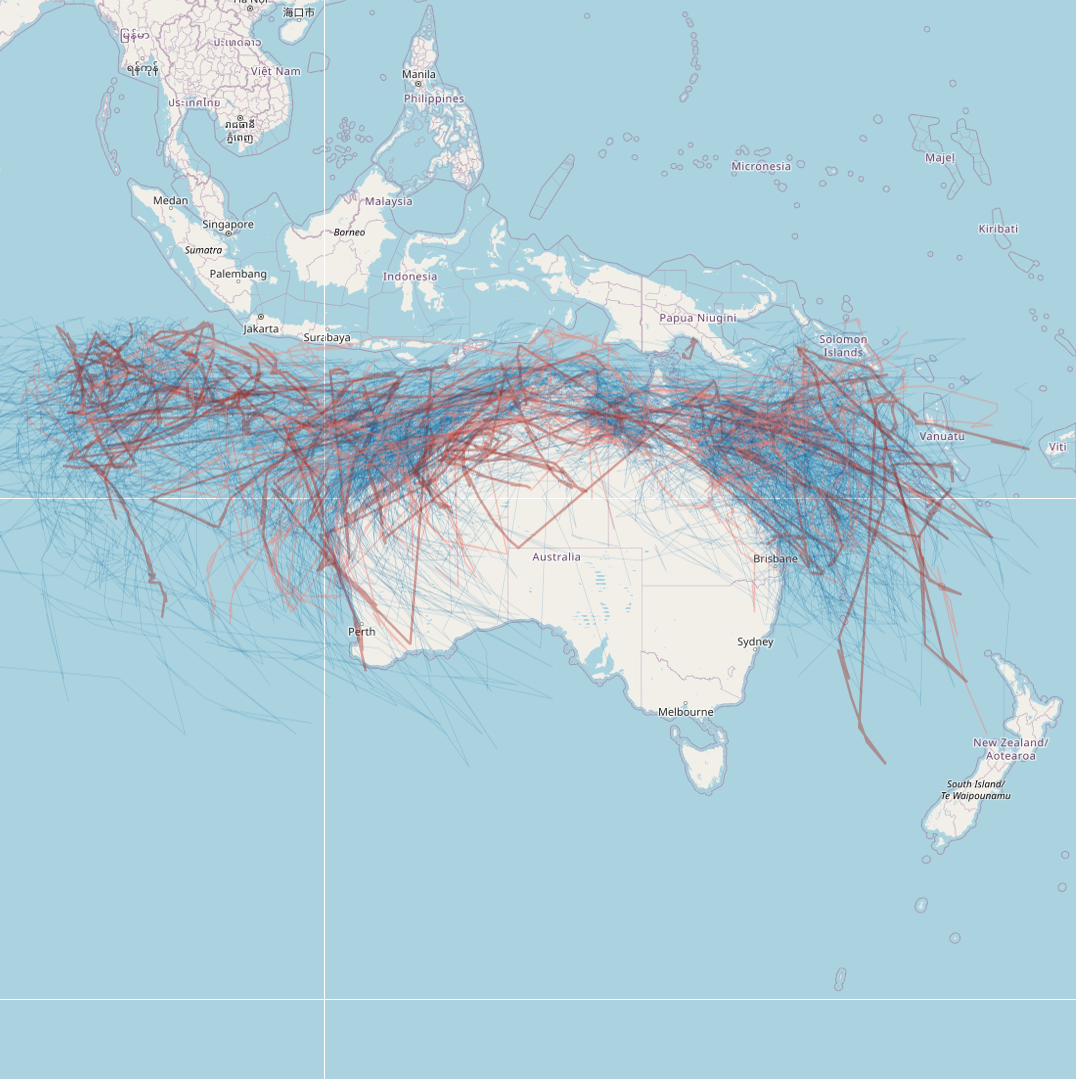
This dataset details all tropical cyclones that are known to have occurred in the region south of the equator between 90E and 160E. The data has been sourced from the Tropical Cyclone Database, maintained by the Bureau of Meteorology (BOM). This record represents a snapshot of the data taken on 23/03/2023 for the purposes of generating a mapping visualisation of recent cyclone activity. The most current database can be downloaded from the BOM website: http://www.bom.gov.au/cyclone/tropical-cyclone-knowledge-centre/databases/ Point data from the BOM has been converted into cyclone tracks for visualisation. The data and mapping layer will be refreshed annually following cyclone season (May-June each year). Last updated 21st November 2023.
-

This record provides an overview of the scope and research data outputs of NESP Marine Biodiversity Hub Project E4 - "Recreational fishing in Commonwealth waters". For specific data outputs from this project, please see child records associated with this metadata. -------------------- Recent assessment have suggested that Australian marine recreational fishers (MRF) are moving further offshore in pursuit of fishing opportunities, which places them in areas managed by the Australian Government. As recreational fishers are key stakeholders in marine management, of MRF effort, catch, motivations and values are required to effectively inform administration of Australian Marine Parks (AMPs) and fisheries. In 2018 the use of exiting MRF state-wide assessment was trialled in WA and NSW to quantify fishing within the Hunter and Ningaloo AMPs. In 2019 this work will be extended to analyse state charter-boat MRF datasets with a particular emphasis on our selected AMPs and the Perth Canyon AMP. Planned Outputs • State of knowledge and gap analysis of recreational fishing in Commonwealth waters (spatial data) • On ground motivation and targets by active fishers of AMP [report]
-

This record provides an overview of the NESP Marine and Coastal Hub bridging study - "Future-proofing restoration & thermal physiology of kelp". For specific data outputs from this project, please see child records associated with this metadata. -------------------- For restoration to be effective, the cause of habitat decline must be understood and overcome. But this is problematic when climate change is driving habitat loss since it cannot be reversed or ameliorated prior to restoration. A previous NESP project led by this team (Project E7, Marine Biodiversity Hub) identified warmwater-tolerant strains of giant kelp from remnant patches in eastern Tasmania, where the species has experienced precipitous declines due to ocean-warming. These strains have high potential to assist with ‘future-proofing’ kelp forest restoration, however it is still unclear what the physiological mechanisms are that provide their improved thermal tolerance. This project is designed to better understand these physiological mechanisms to advance kelp restoration efforts in Australia and globally, and progress toward the identification of populations of Australian kelp that may be resilient to (or especially threatened by) ocean warming and climate change. Outputs • Ecophysiological measurements from laboratory experiments of warm-tolerant vs average giant kelp genotypes [dataset] • Final technical report with analysed data, including a short summary of recommendations for policy makers of key findings [written]
-
Redmap is a primarily a website that invites the community to spot, log and map marine species that are uncommon in their region, or along particular parts of their coast. The information collected is mapped and displayed on the site, demonstrating, in time, how species distributions may be changing. Sightings are divided into two categories – those with a photo that can be ‘verified’ by a marine biologist, and sightings without photos that we call community sightings (anecdotal). All the information collected, with and without photos, is mapped and will be used in the following years to map out a ‘story’ of changes occurring in our marine environment. The main data collected includes the species sighted (normally selected from a list comprising preselected species of interest), the location, date/time and activity being undertaken. Other optional information gathered include biological data such as sex, size and weight and environmental data such as water depth and temperature and habitat. This record is associated with live data (and will subsequently change over time). Note that the accuracy of spatial elements has been reduced for distribution purposes. This data set is also subject to a three year embargo (ie. does not contain data less than three years old). If you wish to discuss obtaining a citable, static dataset, that is current and/or contains precise spatial elements, please see Point of Contact.
-
This data set consists of a scored time-series of Autonomous Underwater Vehicle (AUV) images from the Bicheno region on the east coast of Tasmania. Surveys were conducted between 2011 and 2016 within the Governor Island Marine Reserve and nearby sites outside the reserve. Governor Island was surveyed in 2011, 2013, 2014 and 2016. The outside sites of Trap Reef, Cape Lodi and Butlers Point were surveyed in 2011, 2013 and 2016. Imagery across all surveys was scored for the presence of Centrostephanus rodgersii urchin barrens across rocky reef at each site. Prior to analysis the data was subsetted to every fifth image to avoid overlapping images. The data set also contains depth information for each image and a measure of rugosity (Vector Rugosity Measure) computed in ArcGIS software from a one metre resolution bathymetric map covering the survey sites. Analysis was conducted to examine the trend in the presence of barrens through time and to compare the occurrence of barrens inside the Governor Island Marine Reserve with sites outside the reserve. A spatio-temporal model incorporating both spatial and temporal correlation in the time-series of data was used. This data set contains the scored data used in the analysis. Further details of the methods used and results are contained in the following article. Please cite any use of the data or code by citing this article: Perkins NR, Hosack GR, Foster SD, Monk J, Barrett NS (2020) Monitoring the resilience of a no-take marine reserve to a range extending species using benthic imagery. PLOS ONE 15(8): e0237257. https://doi.org/10.1371/journal.pone.0237257